Photographing and filming of prisoners of war in Canada during the Second World War remained subject to strict censorship policies. Authorized civilian and military photographs took countless photographs of prisoners, primarily so they could be used as postcards, yet films relating to internment operations in Canada remained extremely rare. Only a few such films appearContinue reading “A Rare Glimpse Inside: Camp P (Petawawa) on Film”
Tag Archives: Digital History
Upcoming Presentation: POWs on the Lake of the Woods

This Sunday, August 4th, 2024, Kenora’s The Muse (The Lake of the Woods Museum and the Douglas Family Art Centre) will be hosting a virtual presentation by yours truly. Coinciding with the museum’s new exhibit, Temporary Enemies, Permanent Friends: Prisoners of war on Lake of the Woods, I will be presenting my research on prisonersContinue reading “Upcoming Presentation: POWs on the Lake of the Woods”
Camp 40 (Camp A) – Farnham, Quebec
I whipped this map up for a reader researching his father earlier today and thought I would share. The image shows the layout of the internment Camp at Farnham, Quebec overlaid on some modern satellite imagery from Google. Camp A, as it was initially known, opened in October 1940 and initially held civilian internees andContinue reading “Camp 40 (Camp A) – Farnham, Quebec”
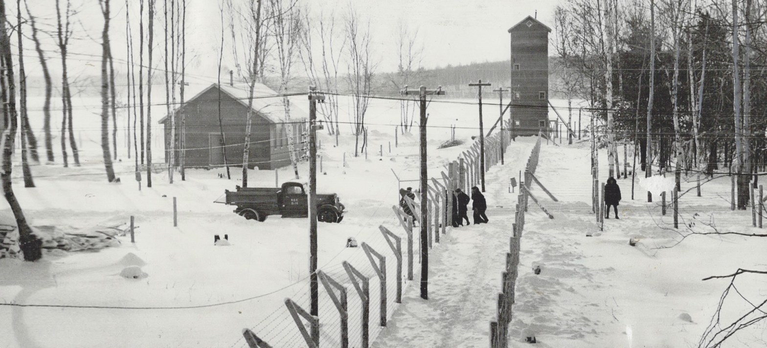
Mapping PoWs in Canada
Few Canadians realize just how close the Second World War came to home, that from 1939 to 1947, Canada held over 34,000 prisoners of war. While many spent their days in one of twenty-eight internment camps, almost half of them were employed on a labour project by the end of the war. With some freeContinue reading “Mapping PoWs in Canada”
Mapping Canada’s Internment Camps
From 1939 to 1947, German Prisoners of War, Enemy Merchant Seamen, and Civilian Internees were held in twenty-eight different locations in Canada. While thousands were eventually employed in small, low-security labour projects, these twenty-eight camps formed the backbone of Canadian internment operations. As part of my research for my PhD, I am attempting to mapContinue reading “Mapping Canada’s Internment Camps”
Exploring and Sharing the Past with iGIS
This post is long overdue but better late than never! About a year-and-a-half ago, I started using iGIS, an iOS app that allows you to visualize geospatial data on your mobile device. My Professor, Josh MacFadyen, had demonstrated the possibilities of this app in our digital history class and I was eager to find waysContinue reading “Exploring and Sharing the Past with iGIS”
Camp 30 – Bowmanville: Then and Now
Following the popularity of my Fort Henry post, I thought I would share a brief look at another important internment camp in Canada – Camp 30 near Bowmanville, Ontario. Approximately seventy-five kilometers east of Toronto, Camp 30 was built around a former boys training school on the outskirts of the town. Camp 30 opened inContinue reading “Camp 30 – Bowmanville: Then and Now”
Camp 31 – Fort Henry: Then and Now

Of all twenty-eight-or-so internment camps in Canada during the Second World War, I can only think of five that have either changed relatively little or haven’t been completely destroyed (at least from the external appearance) in the last seventy years. Among these few is Camp 31 (originally Camp F) at Fort Henry in Kingston, Ontario.Continue reading “Camp 31 – Fort Henry: Then and Now”
Juno Beach: Then and Now
To mark the 70th Anniversary of the D-Day landings, here is one of the projects I have been working on. Earlier in the year, the Laurier Military History Archive released thousands of aerial photographs taken during the Second World War. Among the collection was a number of photos taking during reconnaissance missions leading up toContinue reading “Juno Beach: Then and Now”
Interactive Exhibit – Video
Bit of a delay since my last post, my apologies! As I get back into the swing of things, I hope my posts become a bit more regular. Just a quick post today – a short video showing off my project for the Interactive Exhibit Design. Fellow PhD Candidate Steve Marti recorded and produced aContinue reading “Interactive Exhibit – Video”
