Today, I attended the German-Canadian Remembrance Society’s annual German Remembrance Day (Volkstrauertag) service at the Woodland Cemetery in Kitchener, Ontario. Honouring the sacrifices made by veterans on both sides as well as the victims of war, this moving ceremony was attended by representatives of the Federal Republik of Germany, the province of Ontario, the citiesContinue reading “Volkstrauertag – German Remembrance Day”
Author Archives: Michael O'Hagan
Sketchup Learning Curve
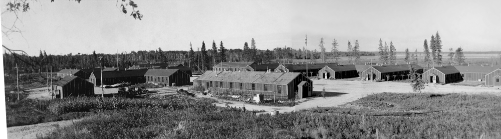
Now that I have my GIS basemap to work from, my next project is creating a 3D model of the camp with SketchUp. While I really don’t have any experience with modelling, here’s what I’ve been working on recently. This is one wing of a standard H-Hut that served as barracks for the PoWs atContinue reading “Sketchup Learning Curve”
Lasting Effects: PoWs in Riding Mountain National Park
The following video is the result of a digital history assignment that I’m currently taken. The assignment tasked us with using digital methods to examine a significant or interesting landscape and naturally I chose the site of the Riding Mountain Park Labour Project in Manitoba’s Riding Mountain National Park. For those not familiar with it,Continue reading “Lasting Effects: PoWs in Riding Mountain National Park”
Lest We Forget…
I hope everyone can take the time today to remember the sacrifices made by our men and women in uniform. Among many others, today I honour my grandmother, Sergeant Isa O’Hagan (Swan) who served with the South African Medical Corps in Italy during the Second World War. They shall grown not old, as we thatContinue reading “Lest We Forget…”
Adventures in Arc – Part II
Here’s the “teaser” of what I have been working on. This is an excerpt of a longer that video that looks at how German PoWs transformed a little part of Riding Mountain National Park.
Adventures in Arc – Part I
Having moved over my GIS project over to ArcGIS over the weekend, I though I’d share my progress. While I’m still trying to adapt to differences between QGIS and the Arc family, I can definitely see the advantages in using these programs. Arguably the most significant advantage of ArcGIS is its tools for spatial analysisContinue reading “Adventures in Arc – Part I”
October 26, 1943 – PoWs Arrive in RMNP
Re-blogged from Manitoba’s Prisoners of War October 26, 1943 Dauphin, Manitoba A train with a rather unusual cargo was stopped on the outskirts of Dauphin just before noon. Immediately following the train stopped, armed guards disembarked and established a secure perimeter on all sides of the train while empty trucks from the nearby Air ForceContinue reading “October 26, 1943 – PoWs Arrive in RMNP”
Website Updates
I’ve added some new pages to the website about my research of German Prisoners of War in Canada during the Second World War. These pages can be accessed by click the “PoWs in Canada” at the top right of the page or by clicking here. I’ve also included a list of internment camps in Canada,Continue reading “Website Updates”
Making Progress with HGIS
Having completed Monday’s HGIS workshop with Don Lafreniere, I have to say that, after going in with experience in Quantum GIS and some ArcGIS, I found the workshop significantly less daunting than my previous time with Arc. Overall, I’m impressed with what ArcGIS has to offer and I’m looking at different ways to incorporate itsContinue reading “Making Progress with HGIS”
Digitized Colour Photos of the Canadian Army
I apologize if this is old news, but I was just made aware that Library and Archives Canada finished digitized their “ZK” prefixed photos. Taken between WWII and the mid-1960s, the collection includes over 3,600 colour images of the Canadian Army. More information on the collection is available here and a finding aid is alsoContinue reading “Digitized Colour Photos of the Canadian Army”
