Having completed Monday’s HGIS workshop with Don Lafreniere, I have to say that, after going in with experience in Quantum GIS and some ArcGIS, I found the workshop significantly less daunting than my previous time with Arc. Overall, I’m impressed with what ArcGIS has to offer and I’m looking at different ways to incorporate its features into my own research. Right now, I don’t have the spatial data to do all of the things I’d like to but perhaps one day.
In the meantime, I’ve been continuing my research with Quantum GIS, which doesn’t have the same features as ArcGIS but still provides me with most of the tools I need at the moment. Over the past few weeks, I’ve been working with QGIS to map the site of the Riding Mountain Park Labour Project. This project, located in Riding Mountain National Park, employed 440 German Prisoners of War from October 1943 to October 1945.
Using a topographical basemap from Natural Resources Canada, I began mapping my project. Fortunately for me, Manitoba Conservation’s Manitoba Land Initiative provides a wide range of geo-spatial information for the province at no charge! I reviewed their sources and downloaded various maps including topography, hydrography, road systems, land parcels, and vegetation maps. Now it was time to add my aerial photographs!

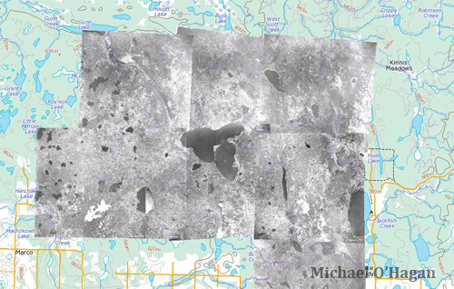
With the assistance of the National Air Photo Library and the very generous support from Riding Mountain National Park, I’ve collecting aerial photographs of the site. At this point, my collection includes images from almost every decade from the 1930s to the 1980s. While the range in quality and scale, they provide an interesting look at the changing landscape of the area surrounding Whitewater Lake. I discovered that georeferencing natural landscapes is significantly more challenging than their urban counterparts. While the earliest period I’m looking at is the 1930s, it is interesting to see what the features that do change (marshes, lakes, creeks, rivers, trails, etc) but to also see the things that generally stay the same. Thankfully there are enough of the latter for me to put these images on the map.
Now, the next step was to add the other historical sources to my map. In my research for my undergrad and Masters, I’ve assembled a fair bit of information regarding the Riding Mountain Park Labour Project but surprisingly little spatial data. In my collection of approximately 3,000-4,000 files relating to the camp, I have a grand total of two historical maps. Thankfully, both are pretty interesting and relevant to my research. Both maps were produced by the Parks Bureau when they were trying to find a location from the camp. The first showed the area affected by a large forest fire in the late 1930s while the second laid out the camp’s initial boundaries. After overlaying these maps, I was able to convert the information to vector layers that I can now manipulate.

I was also happy to find out that I could add my own GPS data. The black line you see on the map below is the route I took in early September of this year.

I was also able to add Google’s Satellite imagery though it appears that the plugin is not compatible with OS Mavericks so that image will have to wait! I’m still working on a few things at the moment so stay tuned in the next few weeks for more!

you’l get it & I’m waiting to see the results
‘